
Behind the Lens: How the Forest Department Tracks Wild Tigers in India
Behind the Lens: How the Forest Department Tracks Wild
Tigers in India
Imagine keeping tabs on a completely silent, apex predator
that ranges across thousands of hectares of dense Indian jungle. For
generations, tracking a tiger meant relying purely on pugmarks
(footprints) left in the forest dust or listening for the frantic alarm calls
of deer.
Today, while traditional tracking remains a fine art, the
ultimate tool in modern wildlife management is the camera trap.
In India—which harbors the vast majority of the world's wild
tiger population—the National Tiger Conservation Authority (NTCA) and state
forest departments execute the largest camera-trapping wildlife survey on Earth
(Qureshi et al., 2024). But how exactly do these little green boxes track big
cats across core habitats and vital forest corridors? Let’s demystify the
science behind the system.
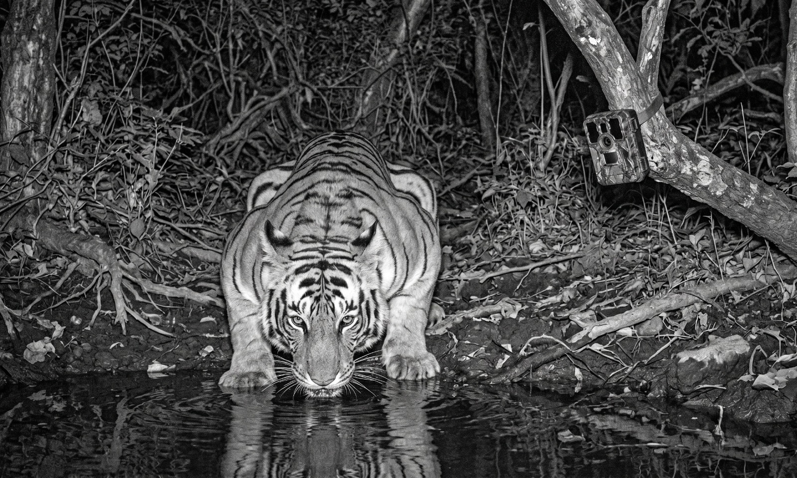
What is a Camera Trap?
A camera trap is a rugged, weather-proof,
motion-activated digital camera strapped securely to a tree that automatically
photographs passing wildlife without human intervention.
By functioning 24/7 in extreme heat, monsoons, and absolute
darkness, these devices provide scientists with an unbiased look at secret
animal behaviors and population numbers.
The Tech Inside the Box
To a layman, a camera trap looks like a simple plastic
container. On the inside, it relies on highly specialized technology designed
not to disturb the target animal.
|
Feature |
Technical Specification |
Purpose for Tiger Tracking |
|
Trigger Sensor |
Passive Infrared (PIR) |
Detects sudden changes in heat and motion across a path. |
|
Reaction Speed |
Less than 0.2 seconds |
Snaps the photo instantly so a fast-moving tiger isn't
missed. |
|
Night Flash |
Invisible Infrared (No-Glow) |
Takes clear black-and-white images at night without
scaring the tiger or altering its natural route. |
|
Power Source |
High-capacity Lithium batteries |
Allows the unit to remain functional for 30 to 45
consecutive days in remote locations. |

Step-by-Step: How the Forest Department Deploys the Grid
Setting up camera traps isn't a game of guesswork. The
forest department uses a highly standardized, scientific protocol across Indian
landscapes (Jhala, n.d.).
1.Dividing the Terrain:Step 1: Grid Mapping.
Forest officials map the landscape into a digital grid
system. In intensive monitoring zones, the area is split into precise 1x1 km
or 2x2 km grid cells to ensure no single patch of forest is left unsampled
(Chatterjee et al., 2023; Gogoi, n.d.).
2.Finding the Wildlife Highways:Step 2: Track
Reconnaissance.
Rangers and seasoned local naturalists walk inside each grid
cell using the M-STrIPES Ecological mobile application (Jhala, n.d.).
They search for physical signs of tiger presence: scratch marks on tree bark,
scats, or fresh pugmarks along forest fire lines and riverbeds.
3.The Double-Flank Setup:Step 3: Camera Alignment.
Once a prime path is found, rangers mount two camera
traps directly opposite each other on flanking trees, roughly 30 to 50
centimeters off the ground. This ensures that when a tiger breaks the invisible
infrared beam, both sides of its body are photographed at the exact same
millisecond.
4.Clearing the Blindspots:Step 4: Perimeter Trimming.
Before walking away, the team clips stray twigs, leaves, or
tall grass within a 15-foot radius. If left untouched, wind-blown vegetation
will trigger thousands of blank "false-positive" images, draining the
battery and filling memory cards.
Decoding the Data: How AI and "Stripe IDs" Work
Once the field cycle ends, memory cards are retrieved. A
single multi-month survey can generate millions of raw photos. Sorting through
them manually used to take months. Today, the data is pushed through
pattern-recognition software platforms like CaTRAT and ExtractCompare
(Qureshi et al., 2024).
The Animal Fingerprint
Just like human fingerprints, no two tigers have the
exact same stripe pattern (Mathur, n.d.). The intricate, black
configurations above their eyes, along their flanks, and near the base of their
tails are completely unique to each individual.
Algorithmic Matching
The software extracts the unique stripe configuration from a
new photograph and runs it against a massive national database.
- If
it matches an existing file: The system updates the individual tiger's
historical log, tracking its health, territory size, and longevity.
- If
there is no match: The software registers a brand-new tiger to the
official system—often a young adult finding its own territory, or a
migrant traveler.
Why Monitoring Forest Corridors Matters
Tigers do not recognize man-made boundaries or national park
fences. To search for new territory or genetic mates, they must travel through forest
corridors—narrow strips of wilderness connecting major national parks
through agricultural zones and human spaces.
Placing camera traps inside these fragile corridors is
critical. If AI logs a specific tiger frequently passing through a corridor
near an infrastructure project or village, the forest department can
immediately redirect anti-poaching camps, set up vehicular speed limits, and
work with local communities to prevent human-wildlife conflict before it can
manifest.
Frequently Asked Questions (FAQs)
How often does India conduct its national tiger
estimation?
India conducts its comprehensive, nationwide tiger
estimation once every four years using a combination of intensive camera
trapping, ground track surveys via the M-STrIPES app, and satellite habitat
mapping (Jhala, n.d.).
Do camera traps harm or disturb tigers?
No. Modern camera traps use no-glow or low-glow infrared
flash systems that are completely invisible to both humans and animals.
This allows the forest department to gather authentic data without altering
normal predatory or territorial behaviors.
What happens if a camera trap gets stolen or destroyed?
Camera traps are housed in heavy, lockable steel casings
chained securely to trees. Many modern models used in highly sensitive
corridors also feature real-time GSM modules that instantly upload images to a
secure cloud server, ensuring the data is preserved even if the hardware is
damaged by weather or elephants.
How do researchers tell tigers and leopards apart on
camera?
The automated AI software platforms (CaTRAT) use
advanced deep-learning computer vision models trained to instantly classify
species based on shape and coat patterns—distinguishing a tiger’s long vertical
stripes from a leopard’s rosette spots within seconds of a data upload (Qureshi
et al., 2024).
For an experiential tiger expedition, contact us
9899893823/9920265051
Korners of India